


You’ve got to walk, better yet, crawl,
on hands and knees over the sandstone,
through the thorn bush and cactus.
When traces of blood begin to mark your trail,
you’ll begin to see something…
maybe.
—Edward Abbey, Desert Solitaire
SPRING, 150– mile Canyon to Diamond Creek
After nearly two months of hiking, we cross the Parashant National Monument on the north rim of the canyon and a new track appears, something I don’t expect. An ATV. Two miles later, we meet two buddies out on an overnight outing. When they see us, they look a bit startled, ashen even. They reveal that due to the remoteness of our location, they thought we might have been “survivors of an airplane crash.”
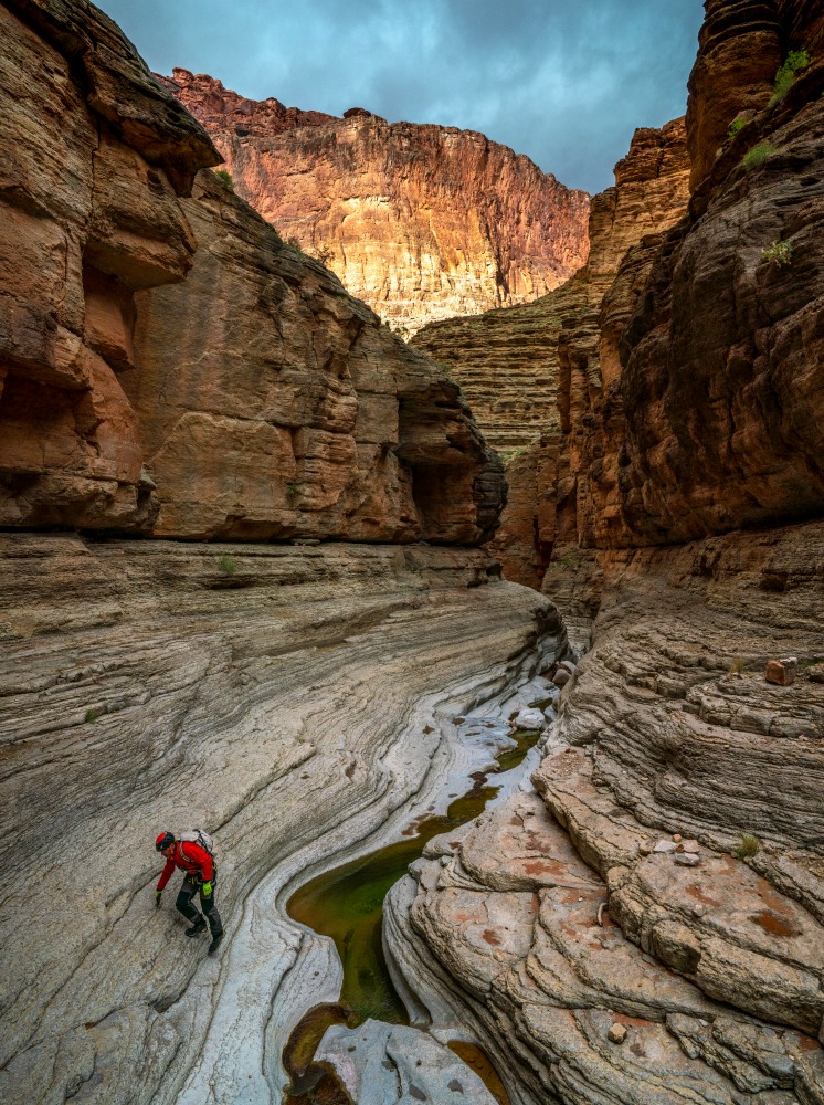
Apparently, we look a bit beat up and rattled. Hiking and bushwacking 15 to 24 miles a day, , can do that.
The further we march west, now on the north side of the river because we are denied a permit to cross the Hualapai tribal lands on the south, it becomes obvious that despite our remoteness and solitude (the ATV guys are the 8th and 9th humans we’ve encountered in 600 miles of hiking), there has been human activity across this landscape for thousands of years – from mastodon hunters to miners to dam builders and ragged hikers.
Western Grand Canyon is vast and then some. As a result, those who know it sometimes refer to the place as “the Godscape.” The endless buttes, the wind-sculpted ribs and mazes of side drainages, some of which are so large they could easily qualify as entire parks on in their own right, create a greater sense of awe and smallness.
At night, when we stop our constant motion, we hear the back-and-forth hoots of owls cutting a silence so deep that I can only describe it as a liquid which floods our ears and everything around us. Occasionally, the cries bleating of bighorn sheep, thousands of feet below us, float into our open-aired camp as we watch the celestial tracks of stars (and satellites) above us until our eyelids give way to fatigue.
The cold and the snow of winter has now melted into the lengthening days of March. Traveling with just Kevin now, we choose to save weight by carrying only a single rain tarp and but never set it up. As long as we can find water, we can bend our bodies to sleep in nearly any rocky depression. It’s amazing how comfortable a slab of sandstone can feel after hiking for 12 hours.
Despite my fatigue, I often lay awake at night: sometimes too wired and worried about finding water or just too spellbound by the spray of stars above us. Kevin describes this celestial sweep as a second river – one that mirrors the main Colorado below us.
Being inside the only canyon on the planet that can be seen from space, you feel miniscule. And when you stare skyward, you realize one of this landscape’s un-spoken marvels is the clarity of its night sky – one of the few landscapes in America without a blanket of light pollution. I lose myself in the space above and the idea that Mother Nature is still queen in these some parts.
As I doze, I overhear Kevin taking audio notes (easier than writing when he is tired) remarkably some 100 yards from me. It is so quiet; I think he is five feet away. He describes these moments “below the river of stars” as if “the canyon is holding us in the palm of its hand”.
It dawns on me that two of the greatest treasures we have encountered in this landscape are not easily captured with digital pixels and cameras.
The first is auditory. When you get beyond the roar of the river inside the canyon, the silence is so profound and so ancient that it escapes description. At times, it makes my ears ring because I’m trying to listen so hard to something that isn’t there. At other times the void of noise is so profound, I wonder if it belongs to another world – a world we have long forgotten.
In the evenings or early mornings, Kevin and I can converse in relaxed, tired voices even though we are a football field apart. The same occurs when we hike, but if a single rib of rock separates us, we can’t hear each holler at the top of our lungs, as if at times, our voices can’t pierce the blanket of quiet that envelops us.
It creates a wondrous and sometimes, nerve-wracking world of quiet.
The second treasure that feels as fragile as the umbrella of quiet emptiness around us is that unfiltered and undiluted night sky. The clarity of Kevin’s “river of stars” is hemmed on the edges by the distant glow of Las Vegas and St. George, Utah. Otherwise, looking across the sweep of erosion, rock and time, there is no sign of civilization before us. Of course, we do see the flow of jet travel blinking above, mostly headed to Los Angeles, but they die down after midnight.
Days earlier, we witnessed ancient paintings in a secret cavern. And not far from it, we collected water from tiny potholes just below a Puebloan roasting pit. The multi-colored paintings are said to be 4,000 years old. Some argue older.
I ponder how these ancient canyon dwellers most likely had gazed on the same vastness, trying to understand it and their place in it. The thought, typically makes me feel small tiny — even irrelevant, not with a sense of futility, but more awe and wonder. I feel lucky to be so immersed in such an ancient, unchanged world.
Some days we find centimeter-deep, potholes from which we use syringes to painstakingly pull the last water from. Other days, we find only cracked earth where rainwater had collected earlier, but has already evaporated into the arid sky. And each day, I try to find new ways to photograph the beauty around us. Considering this park is the most photographed canyon in the world, fighting redundant, cliché imagery plagues my mind as much as our hunt for water.
Kevin and I are alone, but Rich Rudow, all too aware of the dangerous water game we are playing, sends us satellite text messages with coordinates to suspected water potholes that I check twice a day. But even when we get updates, Rich’s information isn’t always accurate since the water puzzle changes daily, hourly even. Two of his most reliable water locations prove dated and filled with dust, forcing us to become entirely dependent on our ability to read the landscape—and rely on some luck to survive.
The story of water in and around the canyon is remarkably complex and mysterious. While water, wind and time are the real artists behind the textured rock canvas, there is little known about how it works. As I attempt to visually capture the complexity of this artery-like network, I’m once again drawn further toward the micro worlds at my feet.
Water travels through layers of rock, hard and soft, meandering laterally and vertically through cracks, crevasses, tunnels and caves. Some of the softer geological layers soak up water like a sponge. But eventually, water emerges somewhere in the canyon – bubbling up in the form of spring or dripping seep — as it tries to reach the Colorado River.
A park hydrologist named Ben Tobin once placed florescent dye in sinkholes scattered on the Kaibab plateau on the north and south rims. Researchers later checked the springs and creeks to see where the dye emerged. One seep, located on the north rim to the east of where we started hiking, surprised everyone.
Based on prior research, experts assumed the colored dye would logically travel flow downstream. It didn’t. Remarkably, it traveled 24 horizontal miles and dropped 6,000 vertical feet. Traces of the dye showed up in a series of springs such as Vasey’s Paradise in Marble Canyon to the west, and Deer Creek, Thunder River, and Tapeats Creek hundreds of miles to the west.
There are two main aquifers in the Canyon, the Redwall and the Coconino, which sit above it. It is believed they are connected, but experts admit, there is little understanding beyond that.
On an overcast morning, Kevin and I walk up a slot canyon where we are delighted and surprised to find water behind a small concrete dam. Above the dam I notice old mining debris; steel wheels, cables, piles of rock. Without much thought, I guzzle my last bottle and happily fill my empties with the clear, silt free water. We treat the water aqua for bacteria and then move on.
Roughly 800 feet above the head of the slot canyon, we come across the Copper Mountain Mine and another swath of debris. We are in the Grand Canyon Parashant National Monument, which was established in January of 2000, transferring roughly one million acres of land from the BLM into the hands of the park service. Prior to that, ranchers and miners explored this remote northern reach of Grand Canyon. We are now hiking hoofing it through the rusted reminders of who came before.
At the entrance to a side shaft, a sign reads: DANGER HIGH RADIATION AREA. Just uphill of the shaft are signs of an abandoned operation. Steel wheels, pumps, pipes, rods, an upside-down vehicle, a collapsing lean-to shed and a swath of rusty cans, gears, boxes riddled with bullet holes, 50-gallon drums, hoses, even a cook stove.
“What do you think of that water we just gulped and loaded up with?” I ask Kevin.
He laughs while looking distressed.
“Yeah, not great, but do we have a better option… or any option right now? That was the first water we’ve seen in miles.”
Evidence of mining exists in and around the Canyon exists and in select patches pockets in the park itself. As we hike, we occasionally see it, but the impacts resonate long after we move on. Three hundred miles upstream, we crossed Horn Creek on the south side of the canyon and although we were thirsty, we kept walking without filling bottles. The park warns visitors not to drink from Horn Creek because of uranium contamination that exceeds EPA standards.
Much of that contamination originates from the orphan mine on the rim next to the park headquarters. Opened in 1893 to mine copper, the orphan mine officially started producing uranium in 1951. It would go on to produce over 4.2 million pounds of uranium oxide plus copper, silver and other minerals. The estimated value of the uranium alone comes in at $40 million.
Today, the orphan mine has been mostly reclaimed after closing in the late 1960s, except for the water below it. In 1995 a research team led by hydrologist David Kreamer of UNLV, measured uranium levels of Horn Creek, the drainage below the mine, and 15 other springs to be above EPA drinking water standards.
Under the fear of water contamination, new uranium exploration around the park was put under a twenty-year moratorium by the federal government in 2012. Current mining operations were grandfathered to continue business as usual and today, the mining industry is lobbying to lift the ban.
Between hiking journeys, I visit the Canyon Mine just south of the park headquarters, the only operational mine near Grand Canyon, to document and better understand the issue. Curtis Moore with Energy Fuels says the uranium ore is “the best in the southwest” and they operate under the strictest environmental regulations in the world. Moore also sees uranium as a job producer and clean fuel for the future. He adds “it’s also the least understood. People hear uranium and they get nervous.”
Days after my visit, a group of some twenty Havasupai tribal members perform a protest outside the mine’s chain-link fence surrounding the property.
“We are the front lines of a water contamination situation,” says Carletta Tilousi, a tribal council member. Tilousi fears the 1,500-foot mine shaft may eventually hit ground water, contaminate it, and will ultimately find its way to the Havasu Creek, much like the researchers’ dye.
Others warn that playing roulette with water in the Grand Canyon is not worth the risk. When dealing with the seventh natural wonder of the world and the Southwest’s drinking water, there is too much at stake, they say.
Hiking now on the Esplanade layer far above the river, we leave the Copper Mountain Mine and its littered history behind. We carry our fill of water from its seep, hoping it’s not heavily contaminated.
Spring temperatures continue to rise, and our ability to find water inversely drops. Perhaps I start questioning if it is not worth risking our survival to keep going. We are just over 100 miles from the northwest border of the park, but there is no value if we perish while trying to reach it.
That night, as we soak up more silence under the current of stars flowing overhead, my canyon sense suggests it might be time to leave. Perhaps it is fatigue speaking after some sixty days of hiking over a dozen miles a day under a heavy pack. Or perhaps I’m more dehydrated than usual.
But as I focus my camera on yet another stunning vista that challenges my sense of scale, I’m certain of one thing. You never conquer this place. With As the author Ed Abbey once mused, time, sweat and luck blood in this place we might begin to understand show something… “maybe”a fraction of it, maybe.
In the heat of spring, with summer knocking on the door, Kevin and I start hearing one message loud and clear—time to exit.